
Amber Snow Warning Issued for North York Moors as UK Cold Snap Persists
Heavy snow and ice expected in parts of England, Wales, Scotland and Northern Ireland amid sub-zero temperatures and travel disruption
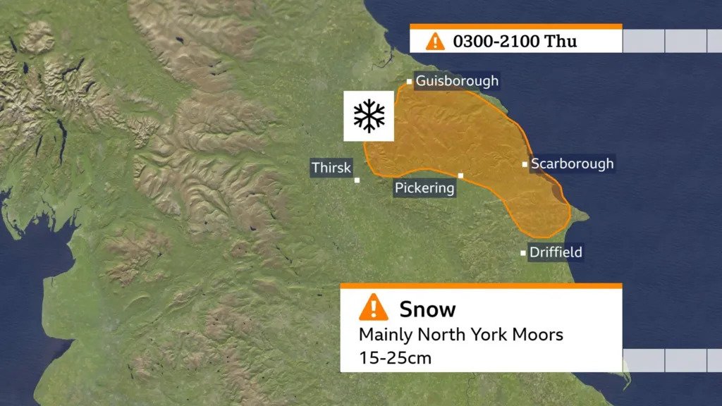
Wintry weather continues to sweep across the United Kingdom, with an amber warning now in force for the North York Moors and neighbouring Yorkshire Wolds where up to fifteen to twenty-five centimetres of snow may fall at higher elevations, meteorologists say.
The alert is active from three a.m. to nine p.m. on Thursday and is accompanied by widespread yellow warnings for snow and ice covering Northern Ireland, northern and central Scotland, south-west Wales and parts of England.
Forecasters say showers or sleet falling on damp ground overnight could rapidly freeze, producing hazardous icy conditions on roads and pavements.
Temperatures on Wednesday night plunged to as low as minus five degrees Celsius in Scotland and northern England, and around minus three elsewhere in England and east Wales.
Daytime highs on Thursday are expected to remain between four and six degrees Celsius in most areas.
The UK Health Security Agency has issued cold-health alerts in England until Saturday, warning of significant risks to older people and those with underlying health conditions.
School closures have already been reported in the Highlands and north-east Scotland, and major routes including the Woodhead Pass in Derbyshire and the B4391 in north-west Wales have been affected by road closures due to snow and ice.
Met Office meteorologists also say that the wintry showers feeding in from the North Sea and Irish Sea may deliver a phenomenon known as “thundersnow” in upland areas above 100 metres in the North York Moors and Scotland — a rare event where thunderstorms produce heavy snow rather than rain.
Regional coastal areas such as Pembrokeshire in south-west Wales continue to be affected by persistent showers driven by the so-called “Pembrokeshire Dangler” weather pattern.
While current conditions are severe in places, they are not forecast to match the extreme snowy outbreak from a year ago, when up to twelve centimetres fell in Nottingham and hundreds of schools closed.
Climate-monitoring data confirm that cold spells and ground frosts have diminished in frequency and intensity since the 1980s due to climate change.
As the cold snap lingers, drivers, pedestrians and vulnerable individuals are urged to take precautions: leave adequate time for journeys, use treated main roads, and ensure heating and insulation in homes are optimised.
Conditions are likely to improve by the weekend, with milder air expected to move in and for most parts of the UK to return to average late-November temperatures.