Wintry Conditions Persist Along UK Coasts After Up to Seven Centimetres of Snow
Forecaster issues fresh warnings as Arctic air drives snow and ice for coastal and northern regions
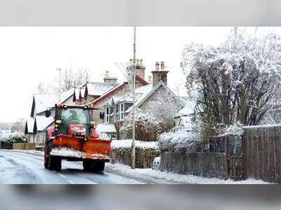
Snowfall of up to seven centimetres was recorded in parts of the United Kingdom as an Arctic airflow brought wintry conditions to exposed coastal regions and northern areas.
The national weather service issued yellow and amber warnings for snow and ice extending across northern Scotland and the east and west coasts, while central inland areas were expected to see brighter and drier conditions.
Overnight and into Wednesday morning, snow was reported in regions including London, Hertfordshire, Berkshire, Surrey, Essex, Shropshire and Northumberland.
A weather station at Lake Vyrnwy in Powys, Wales, recorded a seven-centimetre covering at 8 a.m., and other observations included five centimetres at Lerwick in Shetland, four centimetres at Loch Glascarnoch and seven centimetres at Altnaharra in the Scottish Highlands.
The forecaster warned that the coldest start to the day will be on Thursday, with temperatures expected to fall to minus two degrees Celsius in London, minus one degrees in the Midlands and rise only to one degree Celsius in eastern England.
The main snow-and-ice warning, which had previously covered parts of northern England, has been extended north to the Humber and now includes segments of Lincolnshire.
According to the forecaster’s chief meteorologist, cold Arctic air is now firmly in charge of the UK’s weather, delivering the first notable cold snap of this autumn, and triggering hazards from snow and ice.
The most exposed coastal zones — north Scotland and long stretches of the east and west coastlines — are being primed for wintry showers and accumulations of two to five centimetres, with higher ground in Scotland facing the possibility of 15-20 centimetres and perhaps up to 15-25 centimetres on the North York Moors and Yorkshire Wolds.
Forecasters emphasised that while many central lowland areas will have brighter, drier conditions, the risk of icy roads and pavements remains elevated.
Travellers and drivers in coastal and upland regions were urged to plan ahead, expect slow conditions and allow extra time for journeys as the cold snap persists through Thursday, before gradually easing later in the week.
As the UK enters a sharper transition from autumn to winter weather patterns, authorities reminded the public to heed weather-warning alerts and prepare for sustained chilly conditions with wintry hazards in exposed regions.